Overview
A Raster Map is an image where every zone is defined by a unique colour type. This is used by Yellowfin to detect each unique area of the map and substitute colours based on data in your report.
The raster maps can be used for any type of location reporting not just 'geographic' maps. For example you could use these for:
- Floor Plans
- Car Body Parts
- Network Maps
- Country Maps
How do they work?
With each zone of your map identified by a unique colour you need to link these zones to a specific value. These values are defined as reference codes. With each zone defined by colour and linked to a reference code Yellowfin will be able to substitute the values into the map.
Loading a Raster Map
- To load a Raster Map Image, ensure that your image has unique colour for every region required.
- Ensure that you have reference code setup for your map data. E.g. For the example in Yellowfin you have a country reference code defined by ISO code. These ISO codes will be linked to each zone.
- Similar to loading an image click the add link, provide a name and select map type.
- You will now see a Map details section. For a basic Map you can leave the reference type as None.
- In the layer section you will have to load the actual image you want to use. Maps support multiple layers for the same map. For example you could have a layer for country or region which uses the same world outline.
- On the layer choose the name and description for the image layer that you are loading
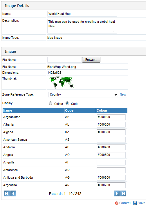
- Browse and upload the map you want to load.
- Choose layer as the layer type.
- Choose the zone reference type. This is used to link the zones to specific reference code values.
- For each colour select the appropriate reference code value.
- Click Save to save your Raster map.
Using a Raster Map
Once the map has been defined you will be able to use it to create heat maps.
- Select the map style chart option and image map from the chart selection list.

- Complete the map details - e.g. select the map you want to use, the layer, and the label (which is the data from your report containing the appropriate reference codes) and click refresh.

See Image Map Tutorial for more information.